How mapmakers keep chaotic traffic under control during a total solar eclipse
&w=256&q=90)

Recently, millions of people traveled to and across North America to view the total solar eclipse in all its glory. To keep traffic flowing smoothly and ensure eclipse seekers knew what to expect on the roads, TomTom’s regional sourcing specialists started preparing months in advance. By the end, they’d mapped over 100 road closures in the U.S., and close to 50 in Mexico and Canada each.
Imagine enjoying a sunny day and suddenly it all goes dark for a few minutes. This incredibly rare event was recently experienced in parts of Mexico, Canada and the U.S. in the form of a total solar eclipse.
On April 8, 2024, the moon passed in between the sun and the earth, blocking out the former and casting a shadow on the latter. Because such an eclipse only occurs once in many years, it drove millions of people to travel across countries for a glimpse. Making sure they got around easily and knew what to expect on the roads were companies like TomTom. The last total eclipse over the U.S. happened in August 2017, where 21 million people traveled from major metropolitan areas such as Portland and Seattle to witness it. With infrastructure unprepared to support this large number, traffic ground to a halt. Drives that, on a normal day, would’ve taken four hours ended up taking over 10 hours.
To avoid such inconveniences this time around, governments and businesses started preparing months in advance. For TomTom, preparation for the eclipse began as early as October 2023, regional sourcing specialist Jay Barry tells me. Tasked with acting as “local intelligence” and gathering the most accurate sources for TomTom’s map, Barry also happens to be an umbraphile — a person who loves eclipses, and often travels to see them.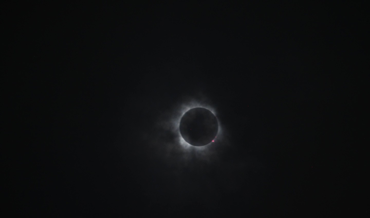 The April 8 total solar eclipse captured by Jay Barry, regional sourcing specialist at TomTom
Preparing for the eclipse
Last year, he started by finding the 115-mile-wide path of totality, which arched from Mexico to Texas to Maine, noting all the major cities that fell on that route. This is where the total eclipse would be visible, and thus, where the highest amount of people would gather.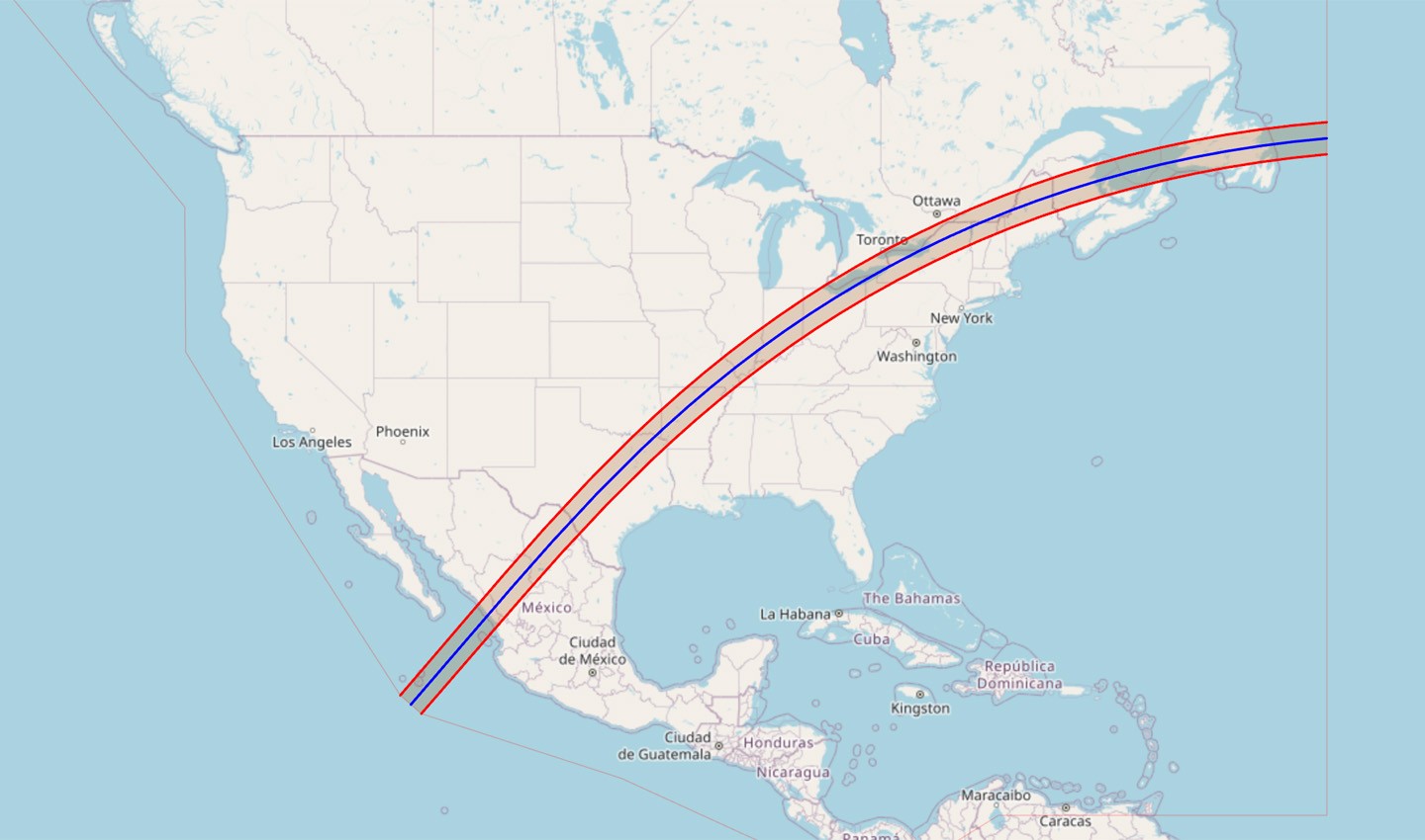 Preparations for the eclipse started with determining the path of totality that stretched from Mexico to Texas to Maine. Credit: eclipse2024.org
Next, he needed to investigate the plans and processes established in each region to prepare for the eclipse. Several states were closing roads to manage traffic and make space for parking. For this, Barry relied on various Department of Transportation (DoT) websites which often map traffic information, including road closures ahead of events. He could then add these closures onto the TomTom map, which is delivered to customers and partners.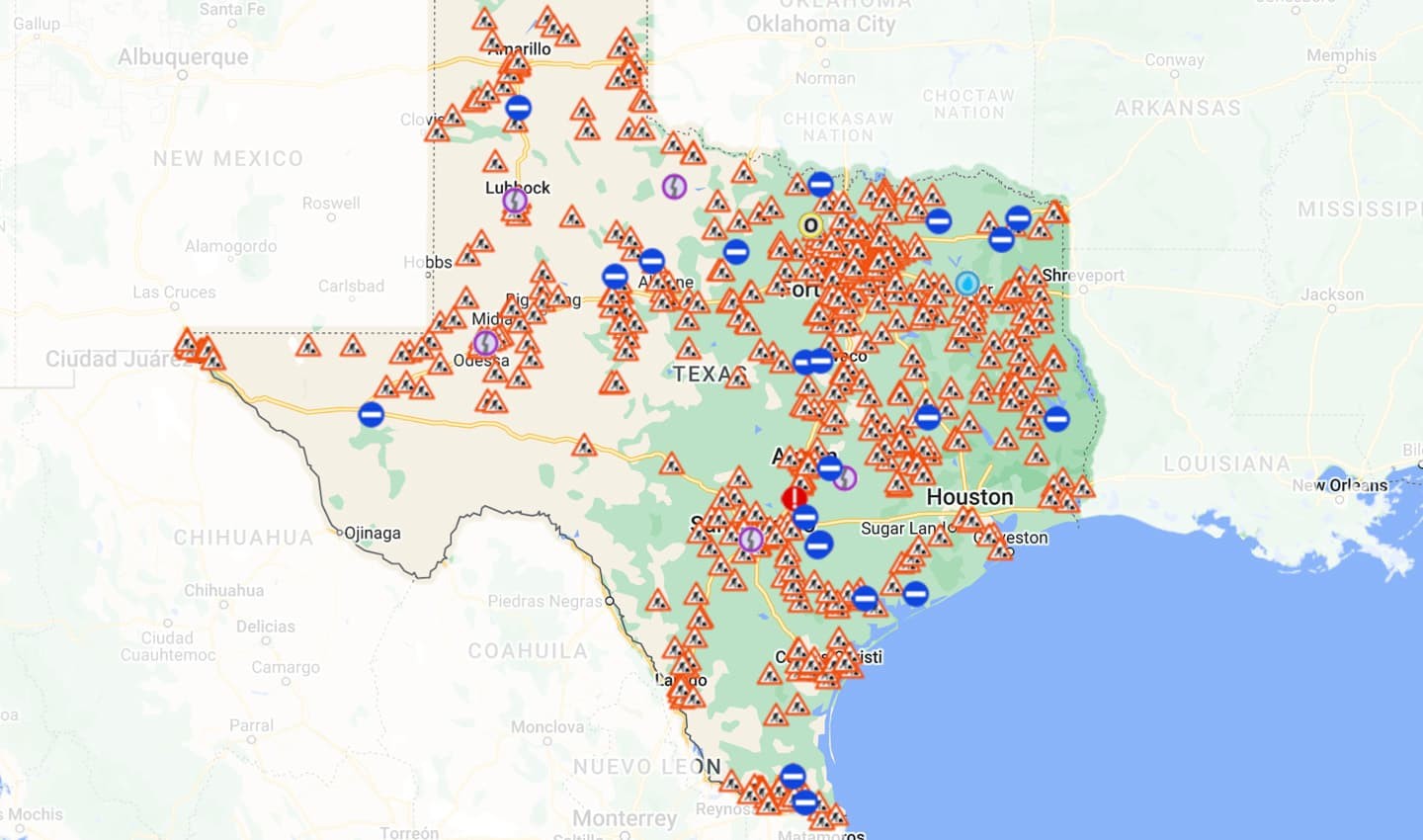 The Departments of Transportation (DoT) in many states map traffic information on their websites, which serves as a handy source for mapmakers. Credit: drivetexas.org
In many states like Texas, there were multiple events and festivals being organized around the eclipse that also demanded areas to be closed off to traffic. Barry’s task also got as granular as finding these events through signs on the road. Closer to the day, he searched social media and the news for any last-minute changes, or updated timings of closures. All this information was promptly updated onto the map. It was also shared with Barry’s colleagues in Mexico and other parts of the region who would be monitoring traffic close to and during the event. He, of course, was off to chase the eclipse.
Closer to totality
Together, Barry and his colleagues stationed in various regions of North America had a plan to monitor traffic on the day of the eclipse so they could update the map with real-time conditions. He advised them to expect traffic one hour before totality, and about four-five hours after. Once they were done for the day, this task was taken over by TomTom’s global watch team that’s based across the globe and is monitoring traffic around the clock.
As the eclipse passed through North America, people started looking at data first in Mexico, then in Texas and all the way to Maine. They were able to see slowdowns, traffic jams and even accidents mapped in real time as the eclipse passed overhead. “One great thing about our map is that at TomTom once we’ve added road closures, we don’t need to remove them manually. Once the map sees that traffic is moving again, it automatically opens up the road,” Barry tells me.
How accurate traffic data helps eclipse chasers
By the end of the eclipse, the team had mapped 134 road closures in the U.S., 58 in Mexico and 47 in Canada. Roads in the Northeast — from New York to Maine — saw the greatest concentration of delays that lasted hours. Several highways had lines of traffic that stretched for miles hours after the eclipse.
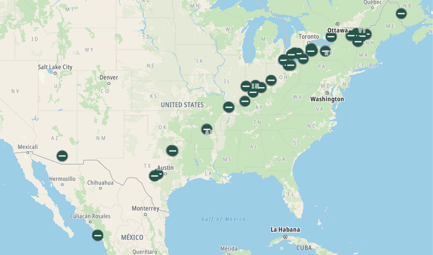 Road closures mapped by TomTom trace the path of the eclipse.
Having access to this information in time helps drives see the road ahead, even if they’re stuck on a highway. They can find out if there are accidents or a blocked road ahead and decide to take an alternative route, which would also in turn relieve congestion on the major roads. This data also informs decisions such as postponing the journey or planning it differently to avoid congestion altogether. Or for a lot of people, it can ensure they get to the prime spot for eclipse viewing.
Keeping traffic moving through the year
A total solar eclipse is a magnificent event that takes a lot of preparation to see and arrange for. With the next major U.S. eclipse set to take place in 2045, the local team won’t need to put in efforts of this kind for a while.
But every event that takes place in and around cities impacts traffic in big ways and small, and sourcing specialists need to be prepared. The local intelligence team maintains an extensive list of major events coming up around the region and prepares for them in the same way as the eclipse. “Everyone appreciates it because no one wants to route a car through the middle of a parade or a marathon,” Barry says
People also read
)
What is traffic prediction and how does it work?
)
Do low emission zones work? TomTom Traffic Index has the answer
)
Q&A: What's happening with global traffic, with TomTom's traffic expert
)
London is still the world's slowest city — highlights from the latest TomTom Traffic Index
* Required field. By submitting your contact details to TomTom, you agree that we can contact you about marketing offers, newsletters, or to invite you to webinars and events. We could further personalize the content that you receive via cookies. You can unsubscribe at any time by the link included in our emails. Review our privacy policy.