Style and substance: How TomTom is taking map visualization further
&w=256&q=90)
There’s a lot that goes into making a great map – and that includes the way map data is displayed. Map visualization determines what we see on maps, and how they come to life in vehicles and apps.
"Visualization is the face of the map. It’s the first thing people see. On this, they base a lot of their understanding and appreciation of the map. You could have the best data in the world, but without great visualization it will never feel or appear to be a great map,” says Rok Erjavec, TomTom’s VP of Engineering Visualization.
It’s clear that what’s shown on the front end of the map matters just as much as the data that goes into building its back end. So, what really goes into making a map both useful and beautiful? In this article, we take a closer look at how TomTom is shaping that reality with its new Premium Map Display visualization tech. But first, let’s start by exploring what’s driving demand for more visually impactful maps in the first place.
People expect more from today’s maps
Maps have come a long way from their paper-based origins. Now, anyone with a smartphone can access incredibly detailed digital representations of the world, held neatly in the palm of their hand.
As maps have become indispensable to our everyday lives, it’s pushing mapmakers to reimagine what that experience should look and feel like. We’ve seen it with the launch of TomTom Orbis Maps, which sets a new standard for both map coverage and visualization (more on this later). Other tech giants have made their own visual advances with things like 3D and immersive views.
Meanwhile, companies like Epic Games and Unity are making moves into the automotive world, using their 3D creation platforms – which started life as video game engines – to power a new generation of vehicle HMIs (Human-Machine Interfaces).
This is in part a response to rising expectations in the auto industry for richer in-car graphics and more advanced digital experiences. After all, as sleek, connected screens come to dominate dashboards, it makes sense that carmakers want to make the most of them. That means integrating more impressive visuals (maps included) that really wow drivers and passengers.
 With digital displays at the center of the in-car experience, map visualization has become increasingly vital for safe, smooth navigation.
This trend isn’t limited to the automotive sector either. Industries from logistics to on-demand delivery all rely on maps to enable their operations. Improved map visualization gives enterprises new insights into their operations and allows them to route and track vehicles, assets and deliveries with greater accuracy. This adds up to better efficiency and bigger bottom-line savings.
We also can’t ignore what’s making many of these changes possible – advances in computing tech. Until a few years ago, computer storage and rendering capabilities limited what we could visualize on a map. Today, cloud computing and high power, low-cost processors, coupled with more powerful AI and rendering capabilities, allow us to do a lot more, creating map visualizations that become three-dimensional, photo-realistic representations of the world.
As these forces converge, TomTom is setting out a clear direction for the future of mapping. The best maps are beautiful maps. And to help make that vision a reality, the company has unveiled a new piece of map visualization technology – TomTom Premium Map Display.
A next-gen visual experience for location data
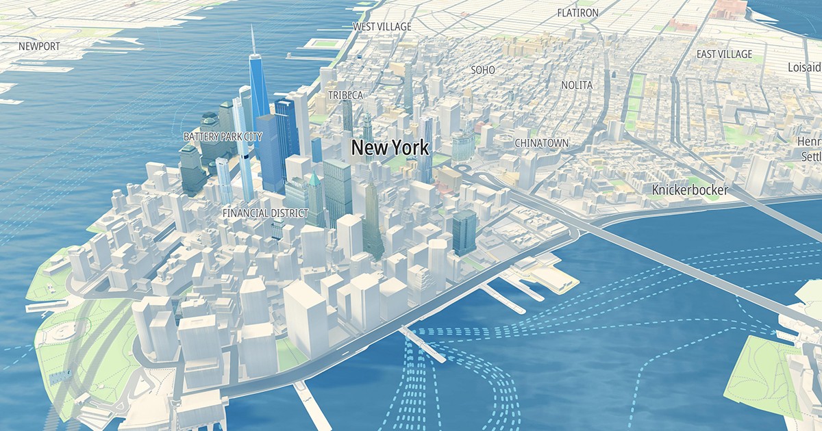
TomTom Premium Map Display, which is powered by TomTom’s new Orbis Maps, allows users to create maps with a highly immersive, realistic and premium look-and-feel.
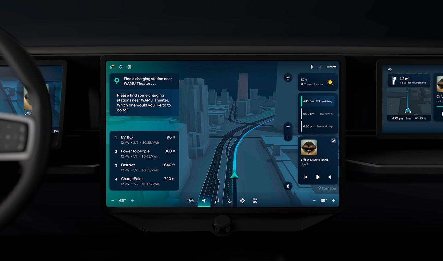
The solution is powered by the same data that underpins TomTom Orbis Maps, and brings map surfaces to life with detailed 2D and 3D visuals and textures, plus overlays of dynamic layers such as traffic, electric vehicle (EV) charging points, lane-level navigation and more.
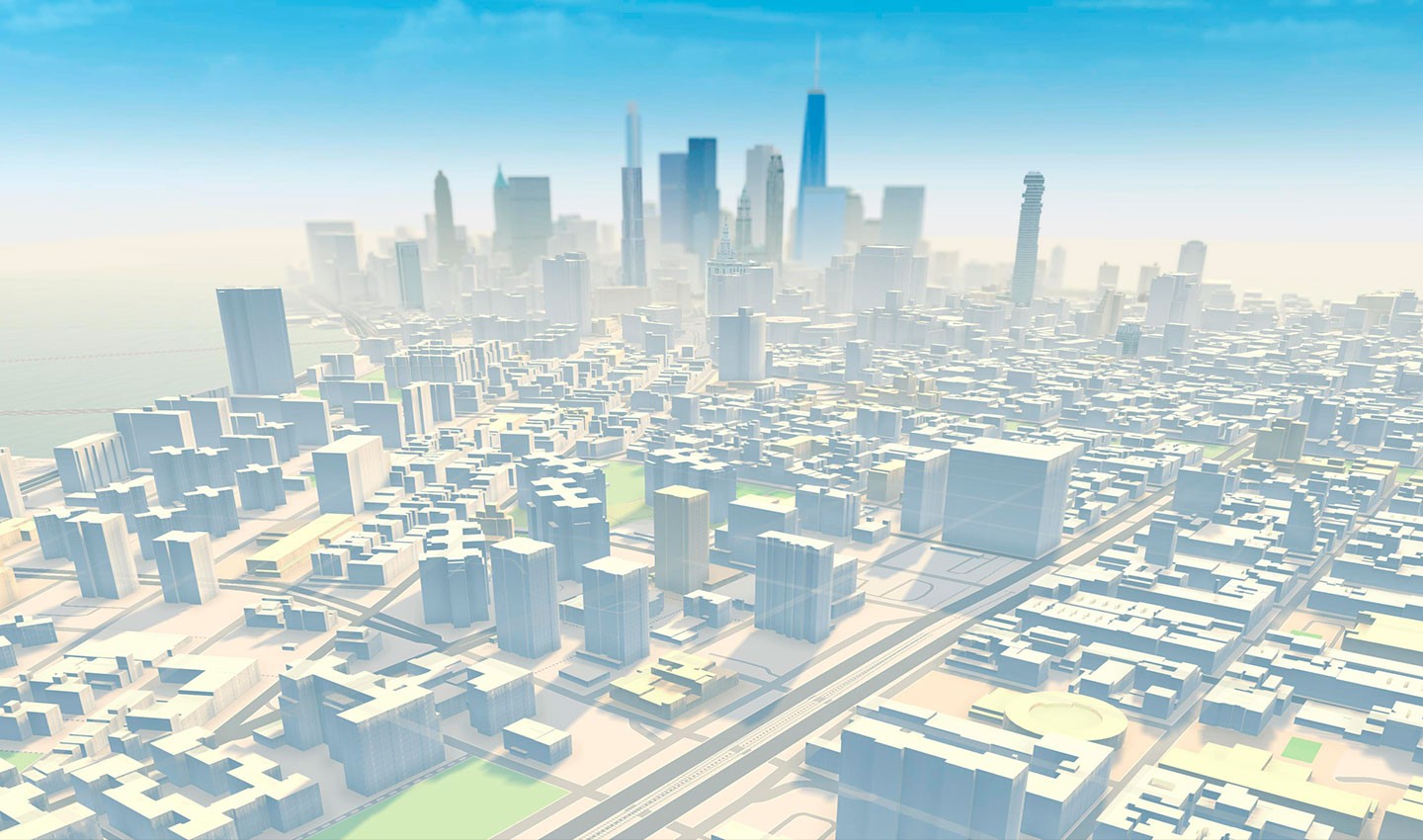
In collaboration with Unity, TomTom has integrated industry-leading 3D visualization into its Premium Map Display. This supports rapid rendering of visually rich features, including elevated roads, high-resolution landmarks and points of interest (POIs), detailed lane markings and terrain.
Not only do these 3D representations elevate the aesthetic appeal of the map, but they also serve an important functional role, enabling improved location awareness and wayfinding. By clearly displaying complex scenarios like traffic flows and junctions, a well-visualized map helps make driving safer and more precise. Likewise, with features like building footprints and shapes visualized in accurate detail, maps make it easier for people to orient themselves – a direct benefit for couriers and on-demand drivers, as well as ride-sharing passengers looking for their pick-up point.
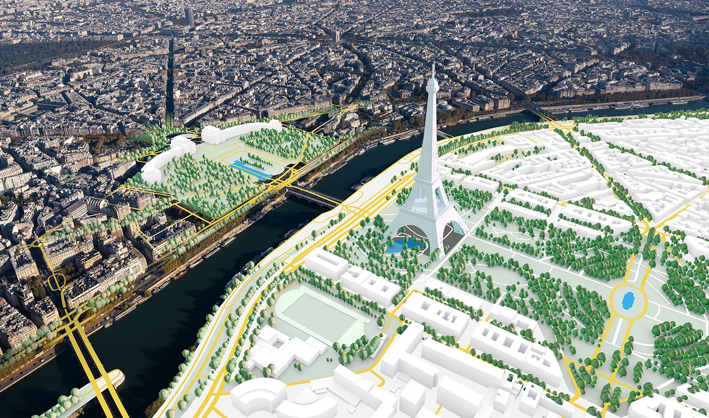
A map that's both beautiful and functional also demands real-time data on dynamic elements like traffic and weather conditions. TomTom’s Premium Map Display and Orbis Maps both incorporate this through overlays of real-time layers such as traffic, electric vehicle (EV) charging points, lane-level navigation and more. Dynamic lighting, shadow models and atmospheric and rendering effects further amp up the realism, making it possible to show fog rolling in across a city waterfront or evening shadows falling on downtown buildings.
“All of this lets us turn that standard view of gray boxes on a map into objects with depth, texture, light and shade. That matters because the more recognizable a map is and the more it matches reality, the more relatable and useful it is,” notes Rok Erjavec.
 Adding atmospheric features like fog to map views brings cityscapes to life in compelling ways.
Making development easier
On top of its impressive visual properties, Premium Map Display provides end-to-end tooling for the entire map design workflow. That includes styling from 2D fundamentals to 3D scenes, as well as fully configurable camera properties to highlight locations from any angle.
Not only is TomTom's solution easy to integrate via different formats – from uncompiled maps to map tiles, APIs and SDKs – it also taps into the power of Unity’s well-established development ecosystem, bringing rich functionality closer to users.
“As our SDK is now seamlessly integrated with Unity, developers can access code and plugins that function within the Unity environment. Designers can customize the look in Unity too without needing an engineer to build use cases and applications,” explains Erjavec.
The richness of the map visualization and the speed at which it can be iterated means that TomTom can serve many more applications and use cases than with traditional tools. The ability to create multiple design iterations in minutes, rather than days, dramatically reduces development costs and effort, making map visualization orders of magnitude more efficient.
“Consider a carmaker with many different brands. They will naturally want to customize the map display in the vehicle to fit each brand’s specific look-and-feel. This is something that previously took three to four weeks to achieve. Now, with Premium Map Display and Map Maker, we can do the same in just minutes,” states Tiago Moreiras, TomTom’s Director of Product Management.
Mapping with meaning
As people navigating an ever-changing world, we often turn to maps to render complex information concisely. Visualization plays a pivotal part in taking all the data we have about a location and bringing it to life in a way that resonates with people – whether they’re a delivery driver navigating a maze of city streets or an urban planner looking for the best location for a new housing development.
When maps look good and are easy to read, users can quickly understand the data they hold and use it to make better decisions. So, map visualization isn’t just about displaying the most visually stunning features or packing the map with as much detail as possible. It’s a careful balance of showing the best, most relevant information to each user, in the clearest way and at the right time.
“We can decide what information will be displayed to the user when navigating at any specific zoom level. At a higher level, minor roads are hidden, and only key POIs are displayed. This has been tested with external users to see what information is needed at every level, as you go from a global view to the highest zoom level,” notes Moreiras.
A look into the future
In the car of the future, map visualization will mean more than just integrating a visually impressive map in a cockpit display. It will be about digitally enhancing reality by juxtaposing map data with augmented and mixed reality techniques.
“This is where we can break the fourth wall and bring the outside world into the car. By merging map visualization with data from vehicle cameras and sensors, we can create an even richer view of the driver’s surroundings across all screen surfaces," comments Erjavec.
With these new techniques, the boundaries between cartography, 3D navigation and photo-realism start to disappear. This creates endless opportunities for representing the world around us and how we make our way through it. And while all possibilities are still open, one thing is already clear. With TomTom Premium Map Display, as we move through our world, its map will look better than ever.
People also read
)
TomTom's VP of Design on the future of in-vehicle experiences
)
Watch the future of driving with TomTom's gen-AI in-vehicle voice assistant
)
See how TomTom Orbis Maps is ready for the future you want to build
)
Inside TomTom’s EV vision: What’s a mapmaker got to do with electric vehicles?
* Required field. By submitting your contact details to TomTom, you agree that we can contact you about marketing offers, newsletters, or to invite you to webinars and events. We could further personalize the content that you receive via cookies. You can unsubscribe at any time by the link included in our emails. Review our privacy policy.