A map historian explains the Netherlands' important role in mapmaking
&w=256&q=90)
In this article, we hand over the keys to the TomTom Newsroom blog to Drs. Reinder Storm who is the Curator Special Collections at The Allard Pierson, a University of Amsterdam affiliated museum that houses a very special collection of historical maps.
Storm takes us through Maps Unfolded, the museum’s current exhibition of important historical maps — running from March 2 to July 16, 2023. He walks us through the collection, what’s on display and the often-poignant histories for which the maps serve as a record and reflection.
Here’s what Drs. Storm has to say:Drs. Reinder Storm on maps and the Maps Unfolded exhibition
Maps help you to find your way and to determine your location. But city street guides, country maps, atlases, globes and route planners reveal more than merely where you are or where you are headed. They also reveal how people see their place in the world.
As well as admiration — for detailed knowledge, craft and graphical beauty — maps also raise questions. They contain a lot of information, but what precisely are they telling us? And what are they concealing? What is the reality that they reflect? From what, once obvious, perspective and with what purpose are they created? Anyone posing these sorts of questions will soon notice that old maps can be surprisingly topical. At the same time, they bear tacit witness to the time and culture they were made in. Given the standards and values of today, you can view them in differing ways.
The Maps Unfolded exhibition, currently running at the Allard Pierson, represents a wide range of different maps, from the 15th century until now, taken from the Allard Pierson’s rich cartographic collection. Many come from a long-term loan from the Royal Dutch Geographical Society (KNAG), which this year is marking the 150th anniversary since its founding.
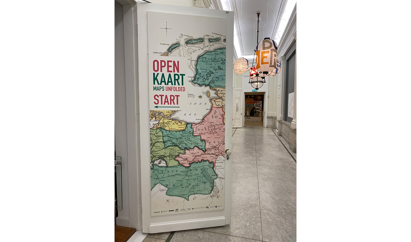 The entrance to the Maps Unfolded exhibition. The exhibit is housed in The Allard Pierson, in Amsterdam. It's no mistake that one of the world's most important mapmaking centers is now showing off its history. Credit: The Allard Pierson.
The exhibition unfolds as you walk through a series of rooms. It starts in Amsterdam, before passing via the Netherlands, Europe and the world to Indonesia, Suriname and the Antilles to explore the Netherlands' colonial past. Key artifacts and interviews provide in-depth information and a range of perspectives on the maps. Insights into modern and dynamic cartography of the future, from TomTom, conclude the exhibit.
Amsterdam on the map: Where it all beganAs you enter the first room of the exhibition, you’ll observe Amsterdam’s story and history as one of the world’s most prominent powers in global mapmaking, trade and development. As you walk through, you’ll see Amsterdam’s history reflected in the maps.
At the start of the 16th century, Amsterdam’s medieval core began to expand. The turbulence caused by the Protestant Reformation led many merchants, artists and craftspeople to flee the Southern Netherlands for the relatively freethinking Amsterdam: with them, they brought a major boost to trade, the creative industries and shipbuilding.
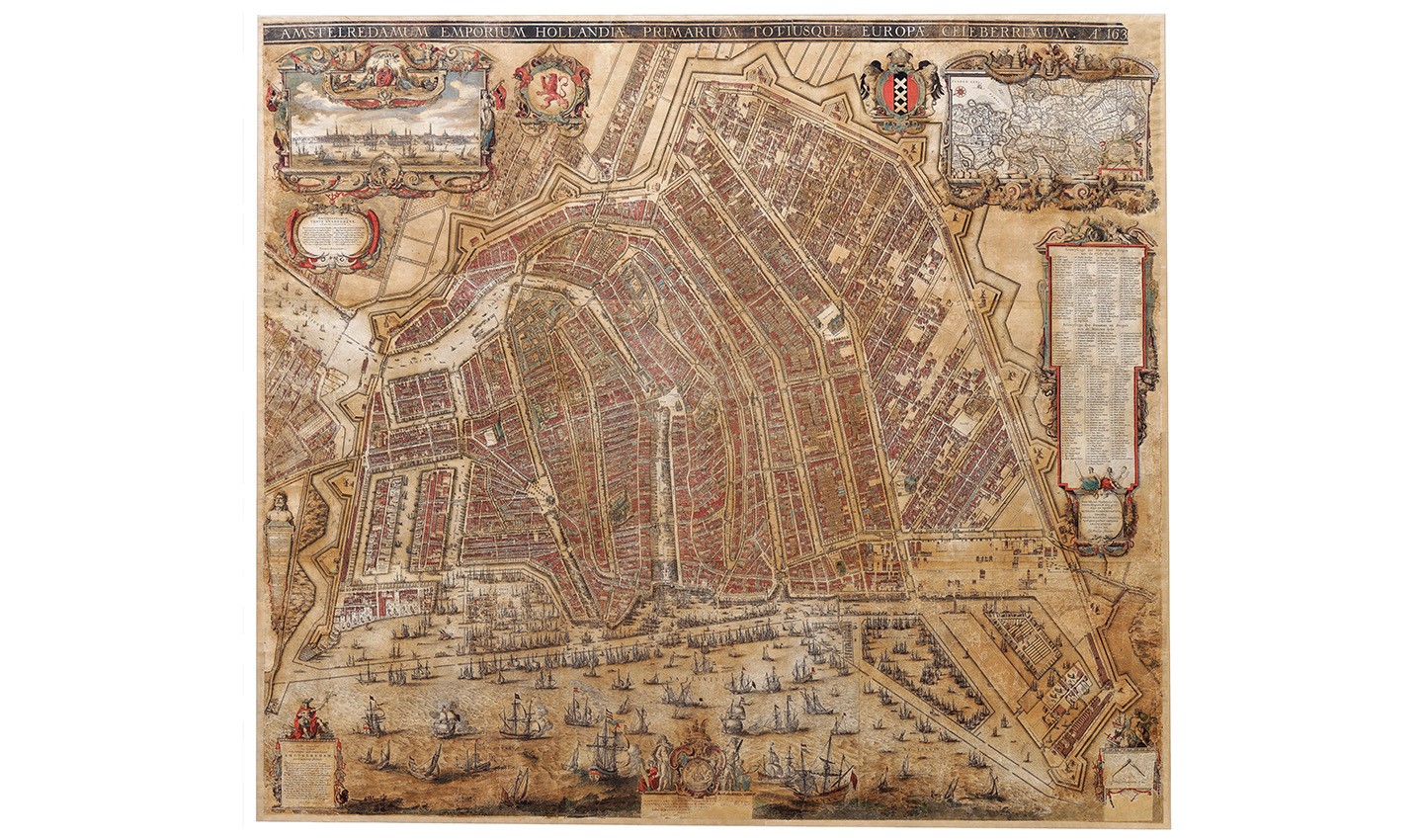 Map of Amsterdam, from 1625. Observing the map, it's clear to see how the trade city was percieved, or wanted to be percieved, by the rest of the world. The vast number of ships indicate the city's importance as an international hub of trade.
The establishment of the Dutch East India Company (VOC) and the Dutch West India Company (WIC) at the beginning of the 17th century turned Amsterdam into a global trading hub and generated great prosperity for the upper social strata — at the expense of widespread violence and slavery overseas. There was more than enough capital. From 1578 onwards, the city expanded up to four times, adding canal rings, islands and new residential areas, like the Jordaan.
Following the Disaster Year of 1672, Amsterdam lost its position as North-Western Europe’s main transit port. Only the WIC flourished, on account of trans-Atlantic triangular trade: merchandise is shipped from Western Europe to the West African coast to be exchanged for gold, ivory and enslaved people. The latter are transported to the Caribbean to be sold and forced to work on plantations. The plantations’ sugar, coffee and tobacco, would then be shipped to Western Europe for sale at a large profit. A patrician elite – the Regenten – profits from all of this, while the gulf between rich and poor widens.
The city starts to grow again in the 19th century as a result of industrialization. Large numbers of laborers abandon the countryside for the city, for a life in slums and basements. Despite spectacular construction plans, the expansion is largely pragmatic. New neighborhoods are created with tall tenements built along narrow streets. Things do not stop there, as is shown by the more recent maps of the city.
An unrivalled highlight of the exhibition is the 1625 wall map of Amsterdam, made by Balthasar Florisz Van Berckenrode. The Allard Pierson acquired it only this year and is proud that this stunning work of cartographic art has been brought back to the city where it was made.
From Amsterdam, zooming out to the rest of The Netherlands
Inhabitants of The Netherlands are accustomed to the borders that shape the country: to the north the Wadden Sea, to the east Germany, to the south Belgium and to the west the North Sea. But through time, this shape was by no means an unchanging given.
In The Netherlands’ room, viewers observe maps dating to before the 19th century. As they gaze upon them, they see that the borders of the region known as The Netherlands have constantly been in flux.
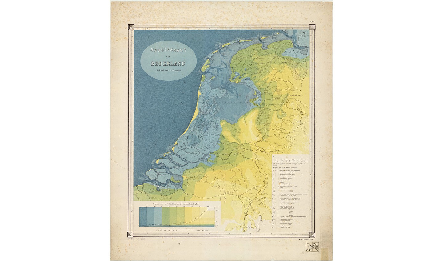 This map of the Netherlands, circa 1865, shoes how regions of land added by the Dutch to their country over the years lay for a significant part under sea level. Credits: Hoogtekaart van Nederland, circa 1865; The Allard Pierson.
Even after The Netherlands was given official outer borders, land regions were added, such as the Flevopolder and the Maasvlakte. The idea that The Netherlands can be seen to some extent as ‘complete’ has come under scrutiny in recent years. Climate change and the growing demand for housing mean that the entire infrastructure of the country is up for reconsideration. What will a map of The Netherlands look like in 100 years? Certainly, different to the maps of today, and even more so to those of 100 years ago.
A political picture of Europe
Geographically speaking, Europe is the second-smallest continent, after Australia. But Europe is the third most populous after Asia and Africa. Europe is made up of many different countries, with as many different languages and cultures. Relations between these countries have long been dynamic and constantly changing. Occasionally, this leads to confrontation and violence, but also to unity and cooperation.
How Europe’s borders have been redrawn again and again, over time, can be readily traced on maps. They paint a detailed picture not just of where one country starts and another ends, but of the political relations between two countries. Within these changing maps are encoded histories that we uncover only as we look deeper.
Europe’s borders have been determined by colonialism, conflict or by succession in royal families. By the middle of the 20th century, moves towards international cooperation took over. Primarily because of two world wars, the desire for: “No more war,” has led to the aims of unity, stability and peace.
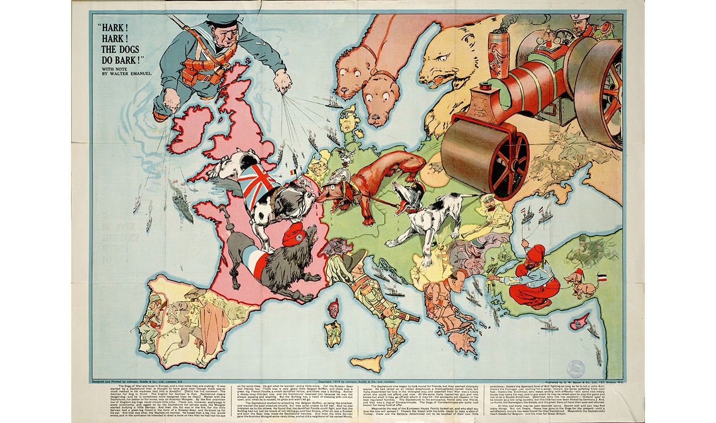 Maps were used to record and display information of all kinds. It's common to think of things like sailing routes, geographies and mountains being drawn on maps, but cultural artifacts have also been recorded on maps. Take this map created by Johnson, Riddle & Co. Ltd., during WW1. The map, held by The Allard Pierson, depicts the world at war.
The rest of the world
As Portuguese, Italian and Spanish navigators embarked on voyages of discovery in the Middle Ages a Eurocentric perspective of the world began to broaden. While in pursuit of knowledge, these quests were largely driven by territorial and economic greed. The trade of enslaved people later became part of this economic and violent expansion.
Through their explorations, the voyagers acquired knowledge about sailing routes, continents and islands, which they all recorded on maps. As their knowledge grew, maps become more and more detailed and specific for their use. New discoveries were constant and were continually incorporated into increasingly detailed maps and globes.
However, for a long time, cartographers knew nothing of the islands they mapped — mapping them only from the observations they made from theirs ships and other landings. Sometimes they drew in animals, non-existent mountain ranges or nothing at all — this explains why some large areas on maps remain blank.
Zooming in to trade and colonialism's impact on mapmaking
Indonesia and the former Dutch East Indies
A vast quantity of maps of what we now know as Indonesia were produced in The Netherlands, over the course of the centuries. This is understandable, given the historical context. There was a large demand for maps starting with the first voyage to the Indonesian archipelago at the end of the 16th century. It all revolved around one thing, whether directly or indirectly: trade. Trade in spices, coffee, tobacco and sugar, and from the end of the 19th century in crude oil as well.
The fact that this exploitation was associated with violence, abuse and slavery is not immediately revealed by these apparently neutral maps – but it can certainly be inferred.
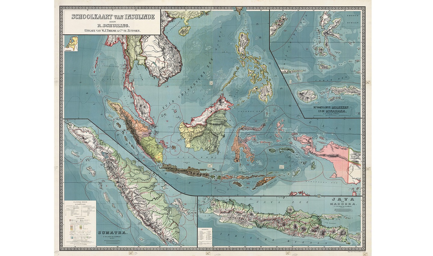 R. Schuiling, Schoolkaart van Insulinde (nowadays Indonesia), The School map of Indonesia, 1898. Collection Allard Pierson UvA.
In the second half of the 19th century a different voice was heard in the colonial debate in The Netherlands for the first time. It provided the impulse for wider anti-colonial views that were unmistakably tied up with the work of the author Multatuli. Multatuli was the pen name of Eduard Douwes Dekker and with his book Max Havelaar (1860) he accused the Dutch government of facilitating serious abuse of local inhabitants. He was not anti-colonial but campaigned for different behavior and new relationships. He marked this by introducing a new name for the empire: Insulinde. It was never formally adopted as the name of the archipelago. But apparently the name Insulinde was used for this map. The fact that Multatuli’s ideas resound in the name on a map more than ten years after he died is intriguing and surprising.
Suriname and the Antilles
In reaction to England’s seizure of the New Netherland colony on the North American east coast, the Dutch moved to occupy the English colony of Suriname on the north coast of South America in 1667. No battles ensued; this was effectively a ‘swap’ for Manhattan in New Amsterdam/New York. England and the Dutch Republic agreed to retain their conquests at the Treaty of Breda the same year and formalize the status quo. These movements explain why the Dutch began making more maps of the region. However, this also marked a start of a painful part of Dutch history, the resulting consequences of differences in wealth, education and opportunity on racial criteria are felt to this day.
This history is characterized by the ruthless pursuit of profit by a small group of entrepreneurs, at the expense of violence, exploitation and racism over two centuries of the transatlantic trade. Ships sailed from The Netherlands with firearms, gunpowder and textiles, these were used to barter with local rulers and slave traders in West Africa in exchange for African men, women and children. The captives were transported to the Caribbean, in particular to Curaçao, Sint Eustatius and Suriname, under inhumane conditions to be sold as plantation laborers. An estimated 15% of the enslaved people did not survive the journey.
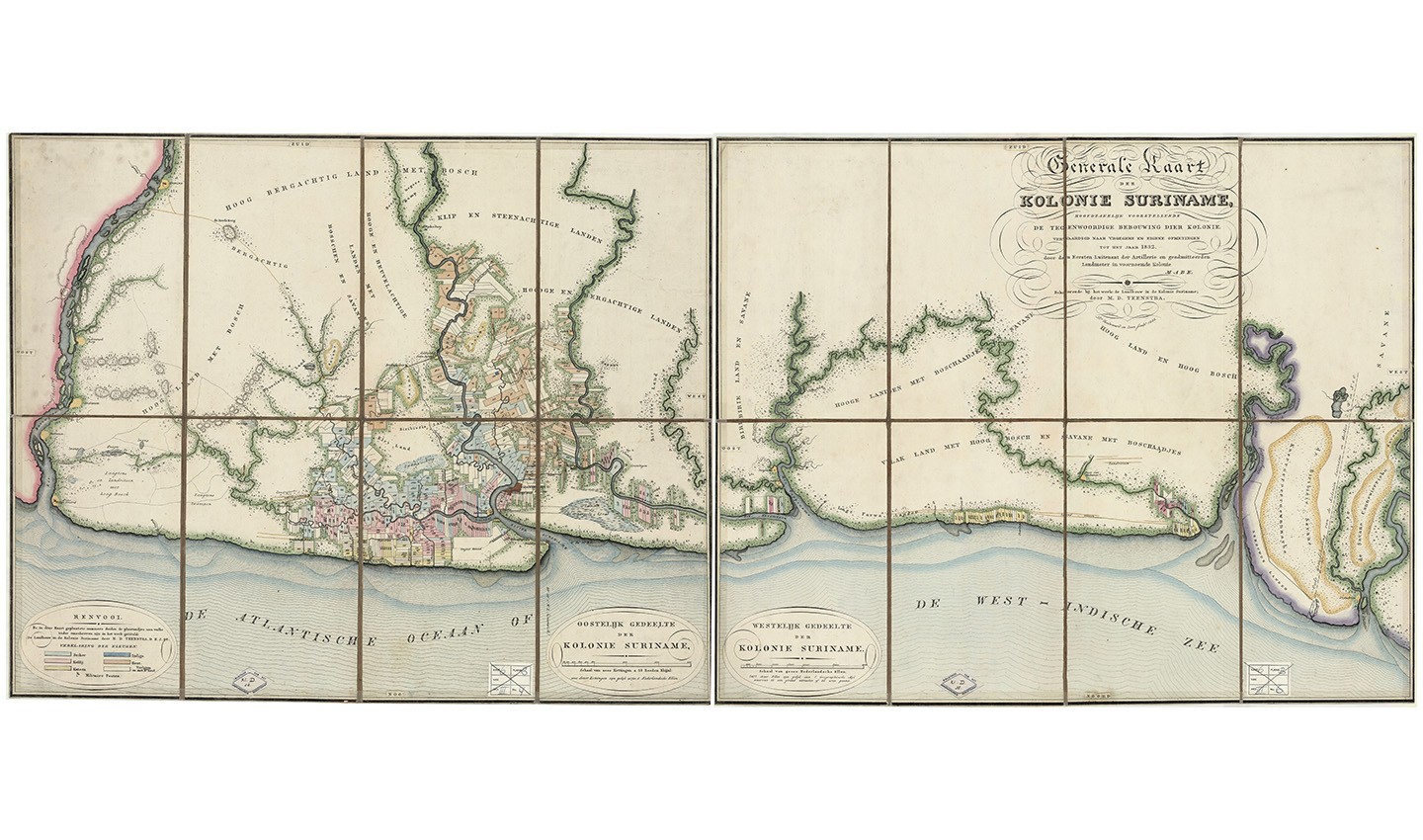 Generale kaart der kolonie Suriname (General map of the colony of Suriname), 1835. Credit: Collection Allard Pierson, UvA.
Following the formal abolition of slavery in 1863, the Dutch state compels the plantation laborers to work for their former owners for 10 years for meagre wages. It is for this reason that many see 1873 as the date that slavery was abolished. This era’s consequences persist for the descendants of the enslaved in the inequality, discrimination and racism that they are confronted with every day.
Towards the map of the future
Coming back to the exhibition: the series of rooms culminates with a look upon the map of the future and the tools modern day mapmakers, like TomTom, are using to make the most accurate and up to date maps ever created.
Entering this room, we fly through time to be brought up to date from the 16th, 17th and 18th centuries. TomTom has put together an exhibition which allows curious minds to step into the philosophies of modern mapmaking.
Exploring this room, visitors will see how digital maps of today are made up of many billions of data points, the maps of the future will be made of even more. And how modern maps are made up of many different layers. They will also see how AI and machine learning, not artists and cartographers, are behind the world’s most used maps and location technologies.
Having just walked through some of the most important years of mapmaking, visitors will be able to reflect on the evolution of mapmaking and how the value and utility of maps has changed over time.
Reflections on Maps Unfolded
Maps are more than just geographical schematics. Within them they encode histories of politics, exploitation, culture and economic development. The longer we look upon them, the deeper we are drawn and the more inspiring they become.
Various contemporary artists have been inspired by the phenomenon of maps and mapmaking. In the exhibition Maps Unfolded - Reflections, works by contemporary artists such as: Gertjan Kocken (1971), Remy Jungerman (1959), Jan Rothuizen (1968) and Qiu Zhijie (1969) can be seen from April 7 to July 16, 2023.
Remy Jungerman has made a work especially for the exhibition in which he reflects on Alexander Lavaux's map, an extensive and very detailed map of Suriname from 1737. See it for yourself at The Allard Pierson and see how you are inspired.
150 years of KNAG
This exploration and exhibition of some of the world’s most important maps wouldn’t be possible without the support of various partners and benefactors. One of which is The Royal Dutch Geographical Society (KNAG). This year, the organization is marking its 150th anniversary.
When it was founded in 1873, the world was focused on exploring undiscovered regions, to equip future expeditions with greater knowledge about these regions. At the time, KNAG was also stimulating the interest of the wider public in geography and improving its teaching in schools and universities.
Particular attention, in the form of scientific, practical and technical investigation, was devoted to the Dutch overseas territories of the time in Southeast Asia, South America and the Caribbean. The belief was that with greater knowledge of the area, there would be more opportunities, and undoubtedly exploitation, to pursue profit.
The KNAG and the University of Amsterdam have shared a special relationship since 1879, when the KNAG entrusted a collection of maps, atlases and other documents to the university library in a long-term loan. This collection – currently held by the Allard Pierson – has grown since then to a formidable size.
Today, the KNAG is active as the professional association of geography lecturers, geoscientists, policy makers and consultants in the spatial domain, as well as many map lovers.
People also read
)
TomTom helps show off Amsterdam's rich mapmaking history, and future, in museum exhibition
)
The world needs a better map: TomTom is making it with its new Orbis Maps and ecosystem
)
What does TomTom Traffic Index data tell us about the world's busiest cities?
)
Meet the trailblazing women that made some of the world’s most important maps
* Required field. By submitting your contact details to TomTom, you agree that we can contact you about marketing offers, newsletters, or to invite you to webinars and events. We could further personalize the content that you receive via cookies. You can unsubscribe at any time by the link included in our emails. Review our privacy policy.